


The Creation of the Slums
In 1914, Norfolk joined many cities across the United States in passing a residential segregation ordinance making it a misdemeanor, punishable by a fine of up to $50, for a white person to live on a block designated for African Americans, and similarly for a Black family to live on a white block. Even after the U.S. Supreme Court found the enforcement of residential segregation ordinances to be unconstitutional in 1917, city leaders continued to assert that this ruling did not apply to Norfolk’s residential segregation ordinance since it applied equally to both Blacks and whites. In 1926 the U.S. Supreme Court ruled in Corrigan v. Buckley that racially restrictive covenants—or clauses listed in property deeds that prevented non-white people from purchasing or occupying a home—were constitutionally enforceable, ensuring that emerging suburban developments would be whites only.
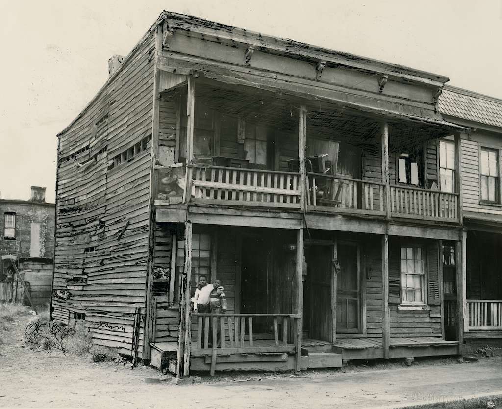
As a result, white neighborhoods, located in the most desirable sections of Norfolk, were protected by law and restrictive deeds from the encroachment of Black populations. As a result, Norfolk’s Black residents were forced into the most undesirable neighborhoods, which were subsequently denied basic public investments in infrastructure. Redlining and other discriminatory lending policies meant that African American residents were routinely denied financing that would enable them to purchase their own homes, forcing many to rent in decaying neighborhoods.

In 1936, the Works Progress Administration (WPA), established by President Franklin D. Roosevelt, conducted a survey of the state of housing in several of Norfolk’s African American neighborhoods. After analyzing 2,000 units, the WPA concluded that less than 10 percent were in good condition, more than a third needed major repairs, more than 75 percent lacked flush toilets and baths, and more than 200 were totally unfit for human habitation. As in other Virginia cities, disinvestment and segregation in Black neighborhoods created blighted housing conditions that were then characterized as “slums.” The following year, passage of the Housing Act of 1937 (the Wagner-Steagall Housing Act) provided federal funding for the clearance of slums and the creation of new public housing. Nathan Straus, the head of the Federal Housing Administration, toured the blighted areas of Norfolk in 1940 and commented that it was “without a doubt the worst slum he had seen anywhere in the United States” and told city leaders that Norfolk would be “first on the list” for redevelopment funds.

Straus’s announcement led to a rush of planning studies in Norfolk that laid the groundwork for what would eventually become one of the largest urban renewal programs in the country. Created in 1940, the Norfolk Redevelopment and Housing Authority (NRHA) was the city’s primary vehicle to marshal federal funds, and by the end of World War II (1939–1945), slum clearance and urban renewal were central to the NRHA’s mission. In 1949 the NRHA hired urban planner Charles Agle to conduct an extensive study of downtown Norfolk and develop a master plan for complete urban renewal. His study described extensive urban blight, and concluded, according to the Virginian-Pilot, that “large scale redevelopment is the only chance the city ever has had to accomplish a drastic modernization of its heart.”
Project One
The Housing Act of 1949 (the Taft-Ellender-Wagner Act) and a subsequent 1954 modification gave cities new power and funding to buy slum properties, demolish them, and resell the land for private development. Soon after the passage of the 1949 housing act, Norfolk became the first city in the United States to receive federal urban renewal funds for slum clearance. In late 1951, the city broke ground on the first urban renewal project in the United States, known as “Project One.” Project One was focused on an area immediately to the east of downtown Norfolk, today known as St. Paul’s Quadrant. After decades of neglect and disinvestment, by the late 1940s this area represented some of the most squalid, blighted neighborhoods in the country. Data collected by housing experts for the 1940 Home Owners’ Loan Corporation (HOLC) “redlining” map of greater Norfolk reported this this area to be 100 percent African American and characterized it as a crowded neighborhood containing frame shacks in dilapidated conditions. Few homes had central heating and most lacked indoor bathrooms. The streets were poorly lit, and the roads were unpaved, flooded frequently, and were full of mudholes and ruts.

Project One aimed to redevelop this area, revitalize the city’s central business district, and restore its real estate tax base. The project would ultimately bulldoze and then redevelop a wide swath between Virginia Beach Boulevard (to the north) and Brambleton Avenue (to the south), stretching west-to-east from Monticello Avenue to Lincoln Street (the current site of Young Terrace public housing), and then continuing east along Brambleton Avenue to Tidewater Drive.
Project One, Norfolk


Unlike later redevelopment projects in Norfolk, Project One partially focused on providing new housing for the African American population it displaced. Although Project One resulted in a net increase in housing for African American families, their housing was concentrated in segregated low-rise public housing developments. Today these developments are known as Young Terrace, Calvert Square, and Tidewater Gardens. City officials included a new school and recreation facilities specifically designed for Black residents in their plans, hoping that these additions would help to relieve the pressure to integrate schools and other facilities in nearby neighborhoods. In addition to the public housing developments, more than one third of the land cleared for Project One was transformed into broad new thoroughfares, highways, and industrial zones that created physical barriers that isolated the new public housing projects from nearby white neighborhoods, maintaining the lines of residential racial segregation.
Project Two
Subsequent waves of urban renewal in Norfolk lacked the limited progressive elements that had been a part of Project One. Over time urban renewal became a vehicle to forestall school integration by maintaining residential segregation following the U.S. Supreme Court’s Brown v. Board of Education decision, which found the doctrine of separate but equal to be unconstitutional.

In 1956, Norfolk Mayor William Fred Duckworth launched a second and even more ambitious urban renewal plan that would ultimately lead to the razing of the city’s last racially integrated neighborhoods. Project Two, as it became known, used federal funds to demolish the integrated neighborhoods of Broad Creek Village, Atlantic City, Lambert’s Point, and a particularly seedy section of downtown Norfolk, while simultaneously creating a buffer to keep Black residents away from Ghent and other white sections of the western portion of the city.
Broad Creek Village was a 584-acre housing project that had been constructed quickly in the early 1940s to house white war workers and military families. The integration of the U.S. military in 1948 resulted in Broad Creek Village becoming more racially integrated than most neighborhoods in Norfolk. Located just east of the city proper, in what was then Princess Anne County, it was a community of some 2,600 households, schools, churches, recreational facilities, and commercial areas. And while the World War II-era housing was cheap and meant to be temporary, the community was anything but a slum. However, once the city of Norfolk annexed the western half of Princess Anne County in 1955, city leaders began talking about the need for slum clearance in Broad Creek Village. Reference to Broad Creek Village as a slum, even if untrue, became a self-fulfilling prophecy. Homeowners and landlords alike were disincentivized from investing in properties, the neighborhood quickly became blighted, thus justifying slum clearance. After the residents were displaced and the land cleared, the property sat vacant until it was ultimately redeveloped into the Norfolk Industrial Park.

Norfolk’s Atlantic City neighborhood was a small, racially integrated, working-class neighborhood of approximately 1,000 households located just west of downtown along the Elizabeth River. The neighborhood was supported by an industrial economy based on the presence of a cotton mill, the seafood industry, and a small boat marina. Due to the wartime housing shortage, by the early 1950s Atlantic City was overcrowded and the exploitation of tenants by landlords was rampant. The 1940 HOLC map of greater Norfolk classified Atlantic City as being 20 percent African American, and described the neighborhood as being made up of a mixture of property types, mostly in poor condition, and many occupied by a “poor class of negroes.” However, Atlantic City was more racially integrated than most neighborhoods in the city of Norfolk. It was one of the only predominantly white neighborhoods where Black families made up more than 10 percent of the population. At the time it was characterized in the Virginian-Pilot as having a “Greenwich Village flavor” and a “Bohemian and cosmopolitan character.”
Similar to Broad Creek Village, city leaders began floating rumors of Atlantic City’s redevelopment. This caused landlords—many who could already be described as slumlords—to abandon even the small amount of upkeep and investment in which they had previously engaged. Thus what had been described as a vibrant, working-class neighborhood just outside downtown Norfolk was effectively pushed into disrepair, which was then used to justify redevelopment. Ultimately, about 1,000 homes were demolished to make way for the construction of Norfolk General Hospital and an expansion of surrounding transportation arteries and tunnel facilities. No new housing was constructed to accommodate those who were displaced as a result of Atlantic City’s redevelopment.


A third area that was redeveloped as a part of Project Two was a small, 37-acre parcel of residential land just north of the Norfolk Southern rail yard known as Lambert’s Point. Like Broad Creek Village and Atlantic City, Lambert’s Point was one of the few racially integrated neighborhoods in Norfolk. The 1940 HOLC map of greater Norfolk described Lambert’s Point as being 30 percent African American, with the Black population concentrated between 44th and 46th Streets in housing that was small and in a state of disrepair. Beginning in the 1950s, the Norfolk Division of the College of William and Mary and Virginia Polytechnic Institute, later renamed Old Dominion University, expanded its footprint, overtaking and razing nearly forty square blocks of the historically Black Lambert’s Point neighborhood. Today, the primarily African American residential section of Lambert’s Point has been reduced to the most environmentally marginalized blocks immediately adjacent to the Norfolk Southern rail yard and coal terminal.

The final neighborhood that was redeveloped as a part of Project Two was a 200-acre section of downtown Norfolk centered around the city’s notorious East Main Street, known as “sin strip” because it was home to an array of bars, honkytonks, flophouses, amusement palaces, and tattoo parlors that catered to the nearby Norfolk naval station. The area also contained some of the city’s worst slums near the downtown business district. The redevelopment of this section of downtown Norfolk resulted in the demolition of more than 400 commercial buildings and nearly 500 residences. As was the case in all other Project Two redevelopments, no new housing—public or private—was built to house those who were displaced as a result of this urban renewal project. Today, East Main Street runs through the heart of what is known as the Waterside district, an area that includes the Hilton, Marriott, and Sheraton hotels, numerous high-end restaurants and commercial buildings, and, as is the case in other areas redeveloped during Project Two, essentially no residential land use.
Taken together, the four areas targeted for redevelopment during Project Two—Broad Creek Village, Atlantic City, Lambert’s Point, and East Main Street in downtown Norfolk—constituted close to 800 acres of land for clearance, twice the size of any development that New York or any other city had attempted. An estimated 20,000 people—almost a tenth of the city’s population—were displaced as a result.
Historian Forrest White argues that the targeting of these racially integrated areas was about more than controlling urban blight. “It aimed to wipe out all of the city’s transition neighborhoods where indistinct color lines had failed to produce two distinct neighborhood school communities, one black and the other white,” he wrote. These same barriers helped maintain school segregation once Massive Resistance and other segregation efforts ended.
Redevelopment of East Ghent

Perhaps the most notorious urban renewal project in Norfolk was the redevelopment of East Ghent beginning in the late 1960s. Situated just north of downtown Norfolk, East and West Ghent were originally developed in the 1890s by the Norfolk Company as an upscale, white, planned community. During World War II, temporary war housing was built in sections of East Ghent, which deteriorated rapidly in the years after the war. With the acceleration of white flight in the 1950s, white families increasingly abandoned East Ghent for the newly developing suburbs further from the city’s center. By the early 1960s, African American families, displaced from other parts of the city as a result of Project Two, began relocating to East Ghent. East Ghent’s population shift was so pronounced that in the 20-year period between 1950 and 1970 the racial make-up of the neighborhood entirely flipped from white to Black. According to the U.S. Census, in both 1950 and 1960 East Ghent was less than 2 percent African American, but by 1970 the same city blocks that comprised East Ghent had become nearly 90 percent African American. Colonial Avenue was as stark a color line as any in the city, dividing East Ghent, which was 90 percent African American, from West Ghent, which was 97 percent white.

It was at this point that city leaders declared the predominantly Black East Ghent neighborhood as blighted. This disincentivized both the city and individual landlords and property owners from investing in the neighborhood’s infrastructure and housing stock, thus creating the blighted conditions needed to justify slum clearance. In 1969 the federal government approved the East Ghent Renewal Project, and soon thereafter the Norfolk Redevelopment and Housing Authority began notifying Black residents that their properties would be acquired through eminent domain. In many cases they gave residents just weeks or months to vacate their homes.
In the end, nearly 90 acres were bulldozed between Colonial Ave (to the West), Granby (to the east), 21st Street (to the north), and Onley Avenue (to the south), displacing yet another nearly entirely African American neighborhood. City officials promised displaced families that they would be able to return to new “affordable” housing in the redeveloped neighborhood. Norfolk didn’t keep its promise and instead built upper middle-class homes and townhomes, expanding the city’s tax base. By the 1980 census, the population of East Ghent was less than 10 percent African American and remains so today.
St. Paul’s Quadrant Today


Today, more than fifty years after its formal end, the legacy of urban renewal reverberates in Norfolk. In 2019 the city of Norfolk and the NHRA received a $30 million Choice Neighborhoods Initiative grant from the U.S. Department of Housing and Urban Development to redevelop the Tidewater Gardens public housing development—one of the public housing projects constructed some seventy years ago as a part of Project One—into new, revitalized mixed-income neighborhood better connected to adjacent downtown Norfolk.
The plan was met by a lawsuit filed in January 2020 on behalf of the residents of Tidewater Gardens, who saw in it echoes of earlier urban renewal displacements of Black communities. City leaders justified the redevelopment because of slum-like conditions in Tidewater Gardens—describing deteriorating homes and high crime and poverty rates—as well as recurrent flooding caused by the development’s location on a flood plain susceptible to sea-level rise. The lawsuit asserted violations of the federal Fair Housing Act in that residents would be relocated to segregated housing and were not guaranteed a right of return to affordable units in their neighborhood. An investigation by the Norfolk Virginian-Pilot found that the majority of the displaced residents did move to low-income, predominantly Black neighborhoods, reinforcing lines of residential segregation.
Following the lawsuit, in November 2020 the Norfolk City Council passed a resolution affirming the right of Tidewater Gardens residents to return to new housing units in the St. Paul’s area and committing to building a sufficient number of units to make this possible. The city settled the lawsuit a year later with a similar promise of right of return. According to the NHRA, the project will replace the 618 units of housing at Tidewater Gardens with 714 units of mixed-income housing, some 500 of which will be designated as replacements for Tidewater Gardens or for low-income households. As of June 2026, 100 of the displaced households have returned to the new Kindred project that is under development.


